

 |
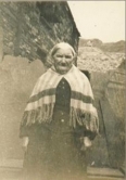
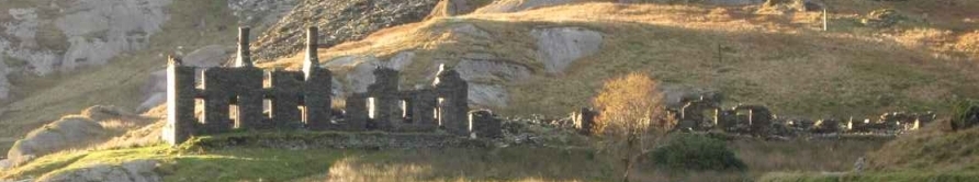
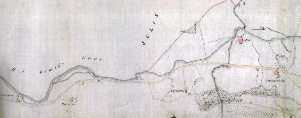
Early access to the cwm Before the establishment of quarrying in the valley, access to the two farms and for travellers passing through was by a steep stepped route up from what is now Tanygrisiau - hence the name which means "under the steps". Descriptions in old accounts by visitors sum up the hazardous journey: Pennant’s Tour in Wales c1781 accounts the following: “About a mile from Cynfael is another comfortable inn [Pengwern Arms] which has often received me after my toilsome expeditions. “Opposite to it lies Cwm Cwmorthin; a retreat more sequestered, and much more difficult of access, than even Cwmbychan. “In my visit to it I descended through woods on a steep road into a very deep but narrow valley which I crossed and began a very hazardous and fatiguing ascent up the rocky front of a lofty mountain: the path narrow and dangerous and, I believe, very rarely attempted by horses.” The journey described is from The Pengwern Arms down to Rhyd-sarn and Cymerau then up to what is now Dolrhedyn and into Cwmorthin itself. A later two-volume chronicle, "Cymru" (A National Dictionary of Wales) by Owen Jones 1875 gives a more descriptive account but in descent from the cwm. “On the hill above the Cwm lies the remains of an old road, said to be that between Cricieth and Llanrwst. Old traditions state that the old Britons preferred to make their roads on high ground to avoid the numerous wild animals that roamed the lowlands. “An inaccessible path reached down from Cwmorthin. There were sort of “grisiau” [steps] near Tai y Muriau to get down to Dol Rhedyn known as the Grisiau Mawr [Great Steps] and it was because of these that the populated area below was know as Tan y grisiau [Under the Steps]. This is also reflected in the book “Hanes Plwyf Festiniog” by G J Williams published in 1882 In the absence of a road from Tanygrisiau Williams wrote “When one wanted to travel from Tanygrisiau to Llanfrothen, Beddgelert etc., there was no option but to go through “Bwlch Cwmorthin” [Cwmorthin Pass]. Steps had to be climbed up the steep slope which was very difficult with an unaccustomed animal” He writes that the Reverend G J Freeman LlB in his book “Sketches in Wales” was amazed to see a tenant of Cwmorthin negotiating such a place on horseback He describes his journey entering the cwm from the north-west as does Owen Jones. “Monday July 4th 1825: We set up a pile of slate rock for a memorial of our visit (Moelwyn) and then departed towards Cwmorthin. “The first part of our way was over a broad morass of peat and heather, the next a most horribly steep descent among rocks and crags that looked like the ruins of nature. In the dreary bottom to which this conducted us, there reposed in gloomy blackness a lake of considerable extent surrounded on all sides by steep rocky hills “On Its shores I counted about half a dozen small patches of oats and potatoes and at the lower end is the abode of the cultivator, a house half smothered with rocks where I din not see a living thing. There were two or three enclosures neat it, whence the stone had been cleared which produced tolerable herbage. Two or three torrents tumbling from the circumambient cliffs feed the pool, which in turn discharges itself in a pretty cascade. “This Cwm and lake, inclosed as they are by mountains that rise to a great altitude, are themselves 1500 feet above the sea; and never, surely, was any spot more gloomy and abstracted. Day light and productiveness must be for more than half the year excluded from it. “The descent is the most extraordinary I have ever made and very toilsome. It is a chain of steps, winding about crags that impend in all directions and I can compare it to nothing better than walking downstairs. “Beside it the river that issues from the Llyn above forms perpetual cascades, sometimes pouring in one sheet over broad ledges of rock, at others, scattering them with infinite divisions of water, and then again hiding its secret tide among hollows and fissures where it roars unseen. “About half way down we met a farmer, on his sure-footed mare, climbing to his mountain tenement. Ere we could pass it was needed that one party to deviate. This the farmer did and descended a little way into a nook in the rocks which I presume he considered as one of his best mowing fields for here there was a green vegetation of flags and rushes. “I was much amused by observing the painful movement of himself and the beast in their progress up these rocky stairs.” Only one map prior to the development of the Cwmorthin slate mine has be thus far been sourced but lacks any relief. A track is marked but more than likely it is a quarry built ‘road’ rather than the original dramatic path. See top of page. However, it does show two dwellings which mark the approach to the cwm. TAI’R MURIAU A pair of houses at the foot of the path leading up to Cwmorthin, they are only recorded on the 1841 and 1851 censuses. Steffan ab Owain in his notes in preparation for a guided walk in 2008 cites that Tai’r Muriau was named after a group of hut circles nearby…. known locally as “Muriau’r Gwyddelod” [Irish walls] The homestead is given a mention in Owen Jones’ “Cymru” in 1875 but the site was buried under the Lower Mills tip probably just after 1861 when the Cwmorthin Slate Company secured the freehold of Cwmorthin Isaf estate and started mining in earnest. Graham Isherwood in his excellent book “Cwmorthin Slate Quarry” states that “The new company immediately began to make improvements; a tramway was constructed down from the quarry to the Ffestiniog Railway near Tanygrisiau which involved the construction of two rope-worked inclines.” The quarry incline running down from the Lower Mills floor to the tramway above Dolrhedyn is called "Tai'r Muriau Incline" after the dwellings that were probably still visible when it was constructed in the early 1860’s. CLYTTIAU was a smallholding marked on the undated map forming part of the Cwmorthin Isaf estate and so far no other information has surfaced. The property would have been buried quite early in the life of the Cwmorthin Quarry as tipping towards the south east progressed. |
Geology - a classic glacial hanging valley
Dyfed Elis-Gruffydd |
Cwmorthin is regarded as a classic example of a glaciated ‘cwm’. Geologist Dyfed Elis-Gruffydd, very familiar with the area since the 1940’s when his father was minister at Tanygrisiau’s Carmel Chapel, summarises the detail of the cwm’s formation and its basic geology. |

Cwmorthin is mainly excavated in the relatively mechanically-weak siltstones, mudstones and slates (metamorphosed siltstones and mudstones) of the Nant Ffrancon Group of mid to upper Ordovician age. However, more resistant intrusive and extrusive igneous rocks (dolerite, felsite and rhyolite) have left an indelible imprint on the landscape in the form of the steep cliffs of Allt y Ceffylau, north of Llyn Cwmorthin, the east-facing cliffs below the summit of Foel Ddu, west of the lake, and the prominent cliffs of Craig Nyth-y-Gigfran and Craig yr Wrysgan-Clogwyn yr Oen to the north and north-west of Tanygrisiau. The cliffs of Craig Nyth-y-Gigfran and Craig yr Wrysgan-Clogwyn yr Oen correspond to the outcrop of the Moelwyn Volcanic Formation (extrusive lavas, volcanic ash, and flows of volcanic debris; the product of submarine eruptions) and intusive rhyolite sills. Furthermore, this suite of resistant igneous rocks accounts for the pronounced narrowing of that part of the valley between the lake and Dolrhedyn. But Cwmorthin owes its present form to the work of ice, for the entire area would have been totally ice-covered during the Last (Devensian) Glaciation which reached its maximum about 20,000 years ago. Cwmorthin is a fine example of a hanging valley whose floor, at an altitude of about 330m near the lake shore, ‘hangs’ about 150 m above the floor of the main valley at Tanygrisiau, itself sculpted by ice flowing in a southerly direction. Bearing witness to the southward-flowing ice is the superb roche mountonée adjacent to the concrete weir above the café/visitor centre at Tanygrisiau. As the name of the village implies, the rock step between Tanygrisiau and the lake is marked by a series of waterfalls and rapids. Furthermore, this section of the valley, in particular, is also characterised by a series of roche moutonées, with steep, plucked downslope sides and smooth and striated (ice-scratched) upslope sides. Other outcrops of the Moelwyn Volcanic Formation are characterised by striking bulbous forms, agin sculpted by the passage of the relatively small Cwmorthin Glacier. The upper, broader section of Cwmorthin, sculpted from the weaker siltstones, mudstones and slates of the Nant Ffrancon Group, corresponds to a large and relatively complex, valley-head cirque basin (not unlike Cwm Idwal), whose backwall has been breached by a col (Bwlch Cwmorthin-Bwlch y Rhosydd). In addition to the valley-head cirque, a ‘tributary’ north-facing cirque basin lies below the summit of Moel-yr-hydd, whose floor is occupied by hummocky glacial moraine. Strewn across the surface of the moraine, composed of till (boulder-clay), are large and small boulders. The combined erosive power of the Cwmorthin-Moel-yr-hydd Glacier scooped out the rock basin now partially occupied by Llyn Cwmorthin. (No data exists relating to the depth of the rock basin nor the lake. The rock bar, which dammed the lake, has subsequently been raised by quarrymen.) At the maximum of the Last Glaciation, the Cwmorthin-Moel-yr-hydd Glacier not only augmented the southward-flowing ice stream at Tanygrisiau (which, in turn, fed the Dwyryd Glacier), but also fed the Croesor Glacier via the Bwlch Cwmorthin-Bwlch y Rhosydd transfluence col, whose floor is at an altitude of about 400 m. The presence of the col clearly suggests that there was a blockage – a surfeit of ice – in the vicinity of Tanygrisiau, and since the Cwmorthin-Moel-yr-hydd Glacier was no longer able to discharge its entire flow southwards, the valley-head cirque backwall was breached, allowing surplus ice to escape in a westerly direction. By about 15,000 years ago the entire area would have been ice-free. However, during a brief cold period between 13,000 and 11,500 years ago, a time when small glaciers reoccupied many of the cirques basins of Snowdonia, it’s possible that a small glacier, or at least a permanent snow-bed, would have re-established itself in the shaded, north-facing Moel-yr-hydd cirque basin. Freeze-thaw action would also have shattered the rocks, resulting in the formation of screes on the lower, valley-side slopes. At this time and during the post-glacial period (i.e. following the warming of the climate post-11,500 years ago), stream erosion led to the partial infilling of the floor of Cwmorthin. The flat ground between the head of the lake and Plas Cwmorthin was once occupied by Llyn Cwmorthin, but is now filled with flood deposits (gravel, sand and silt) from the abundant streams. |
| Visitor Counter: | |||||||
 |  | |  |  |  | ||